Phatthalung city is the oldest of the ancient city in southern Thailand Terrain of the coastal plains and hills about 858 kilometers from Bangkok is approximately 3424.473 square kilometers and a population is 507,777 people.
march.
Contact the north, Nakhon Si Thammarat and Songkhla.
Eastern contact with the lake, Songkhla Province.
Contact the South Songkhla and Satun.
Contact the Trang Province.
Administrative divisions.Phatthalung is subdivided into 11 districts, 65 subdistricts and 626 villages.
1.Mueang Phatthalung
2.Kong Ra
3.Khao Chaison
4.Tamot
5.Khuan Khanun
6.Pak Phayun
7.Si Banphot
8.Pa Bon
9.Bang Kaeo
10.Pa Phayom
11.Srinagarindra
Symbols.
The provincial seal shows the 250 meter high Phu Khao Ok Thalu mountain.
The provincial tree as well as the provincial flower is the Sweet Shorea (Shorea roxburghii).
Phatthalung Tourism.
Phatthalung Province. The topography of the coastal plains and the mountains
make up the many tourist attractions such as mountains, waterfalls, forests and sea,but the popular Tourism in Phatthalung is
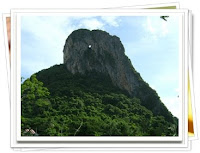
Khao Ok Talu {เขาอกทะลุ} It is a symbolic figure of Phatthalung, having a height of around 250 m.
Phra Phutthanirarokhantarai Chaiyawat Chaturathit or Phra Si Mum Mueang {พระพุทธนิรโรคันตรายชัยวัฒน์จตุรทิศหรือพระสี่มุมเมือง} is the Buddha image of the South and an auspicious object ofworship of Phatthalung.
Rulers’ New and Old Palaces {วังเจ้าเมืองพัทลุง วังเก่า – วังใหม่} Once they served as a residence cum office of the governors of Phatthalung.
Hat Saen Suk Lampam {หาดแสนสุขลำปำ} This sandy beach along the coastal line of Songkhla Lake is fringed by shady pine trees.
Thale Noi Non-hunting Area {เขตห้ามล่าสัตว์ป่าทะเลน้อย} This is the first non-hunting area ever founded in Thailand. Interesting things at the Thale Noi Waterfowl Park are the Thale Noi Palace.
Laem Chong Thanon {แหลมจองถนน} It is a fishing village in Tambon Chong Thanon.
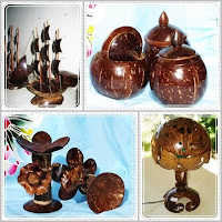
 Coconut Shell Handicraft Centre of Mueang Phatthalung {ศูนย์รวมหัตถกรรมกะลามะพร้าวเมืองพัทลุง} This is a village of handicrafts made from coconut shell.
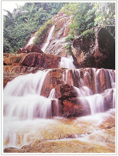
Namtok Phraiwan {น้ำตกไพรวัลย์} This large-scale waterfall is tranquil and full of shady trees.
Khao Pu – Khao Ya National Park {อุทยานแห่งชาติเขาปู่ – เขาย่า}Most of the floras belong to a moist evergreen forest. Wild animals consist of 60 species of mammals.
Khlong Hu Rae {แอ่งน้ำหูแร่} or Hu Rae Canal is large and full of clear and clean water.
Nature Trails {เส้นทางเดินศึกษาธรรมชาติ} There are 2 trails within the area of the park headquarters.
Pha Phueng {ผาผึ้ง} It is a limestone cliff, around 300 m from the park headquarters.
Travel.
Car.
Along the Highway 4 to Chumphon (Pathomporn intersection) and turn right to Ranong, Phang Nga, Krabi, Trang, Phatthalung distance to 1,140 km
Coming to Chumphon Highway 41 to Phatthalung. Distance of 840 km
Coming to Chumphon and then. Through Surat Thani Nakhon Si Thammarat. And on Highway 403 then Highway 41 to Junction He Chumthong Phatthalung
Bus.
Car Transport Company opened between Bangkok - Phatthalung daily.
Rail.
Train services through the District Khuan Khanun ,Khao Chaison ,Pak Phayun.


